


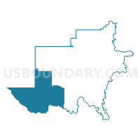
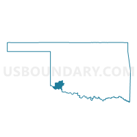
Voting District 18, Jackson County, Oklahoma
About
Outline

Summary
| Unique Area Identifier | 654140 |
| Name | Voting District 18 |
| County | Jackson County |
| State | Oklahoma |
| Area (square miles) | 172.30 |
| Land Area (square miles) | 172.11 |
| Water Area (square miles) | 0.19 |
| % of Land Area | 99.89 |
| % of Water Area | 0.11 |
| Latitude of the Internal Point | 34.47185460 |
| Longtitude of the Internal Point | -99.62989190 |
Maps

Graphs
Select a template below for downloading or customizing gragh for Voting District 18, Jackson County, Oklahoma


Neighbors
Neighoring Voting District (by Name) Neighboring Voting District on the Map
- Voting District 0001, Hardeman County, TX
- Voting District 0002, Hardeman County, TX
- Voting District 0003, Hardeman County, TX
- Voting District 17, Jackson County, OK
- Voting District 19, Jackson County, OK
- Voting District 204, Harmon County, OK
- Voting District 24, Jackson County, OK
- Voting District 302, Harmon County, OK
Top 10 Neighboring County Subdivision (by Population) Neighboring County Subdivision on the Map
- Quanah CCD, Hardeman County, TX (2,979)
- West Jackson CCD, Jackson County, OK (2,043)
- Chillicothe CCD, Hardeman County, TX (1,002)
- Gould CCD, Harmon County, OK (412)
- Goodlett CCD, Hardeman County, TX (158)
Top 10 Neighboring Place (by Population) Neighboring Place on the Map
Top 10 Neighboring Unified School District (by Population) Neighboring Unified School District on the Map
- Quanah Independent School District, TX (3,169)
- Hollis Public Schools, OK (2,891)
- Chillicothe Independent School District, TX (1,185)
- Olustee Public Schools, OK (723)
- Duke Public Schools, OK (664)
- Eldorado Public Schools, OK (628)
Top 10 Neighboring State Legislative District Lower Chamber (by Population) Neighboring State Legislative District Lower Chamber on the Map
- State House District 68, TX (135,942)
- State House District 60, OK (36,383)
- State House District 52, OK (32,109)
Top 10 Neighboring State Legislative District Upper Chamber (by Population) Neighboring State Legislative District Upper Chamber on the Map
Top 10 Neighboring 111th Congressional District (by Population) Neighboring 111th Congressional District on the Map
Top 10 Neighboring Census Tract (by Population) Neighboring Census Tract on the Map
- Census Tract 9501, Hardeman County, TX (4,139)
- Census Tract 9678, Harmon County, OK (2,922)
- Census Tract 9683, Jackson County, OK (2,043)
Top 10 Neighboring 5-Digit ZIP Code Tabulation Area (by Population) Neighboring 5-Digit ZIP Code Tabulation Area on the Map
- 79252, TX (3,202)
- 73550, OK (2,512)
- 79225, TX (976)
- 73560, OK (829)
- 73537, OK (643)
- 73532, OK (600)
- 73544, OK (268)